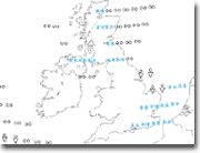
Modèle:
Mise à jour:
4 times per day, from 06:00, 12:00, 18:00 and 00:00 UTC
Copyright:
This service is based on data and products of the European Centre for Medium-Range Weather Forecasts (ECMWF)
Source: https://www.ecmwf.int
Licence Statement:
This ECMWF data is published under a Creative Commons Attribution 4.0 International (CC BY 4.0).
Link: https://creativecommons.org/licenses/by/4.0/

The maps produced by WeatherOnline are subject to the Terms and Conditions.
Disclaimer:
ECMWF does not accept any liability whatsoever for any error or omission in the data, their availability, or for any loss or damage arising from their use.
Greenwich Mean Time:
12:00 UTC = 13:00 CET
Résolution:
0.4° x 0.4°
Paramètre:
Kind of precipitation
Description:
kind of precipitation   Rain or shower? This chart shows the kind of precipitation that is likely to fall given the atmospheric and surface conditions at a certain place.

The following table explains the symbols:

Precipitation Light Moderate Heavy
Rain
Rain shower
Snow
Snow shower
Sleet
Freezing rain
Cloud Cover 0-2 3-4 5-7 8
(eights)
NWP:
La prévision numérique du temps (PNT) est une application de la météorologie et de l'informatique. Elle repose sur le choix d'équations mathématiques offrant une proche approximation du comportement de l'atmosphère réelle. Ces équations sont ensuite résolues, à l'aide d'un ordinateur, pour obtenir une simulation accélérée des états futurs de l'atmosphère. Le logiciel mettant en œuvre cette simulation est appelé un modèle de prévision numérique du temps.


Prévision numérique du temps. (2009, décembre 12). Wikipédia, l'encyclopédie libre. Page consultée le 20:48, février 9, 2010 à partir de http://fr.wikipedia.org/w/index.php?title=Pr%C3%A9vision_num%C3%A9rique_du_temps&oldid=47652746.